After the death of Moses, the mantle of leadership
passed to Joshua, and it was he who led the nation across the Jordan River into
Israel.
The first thing the Jews turned their attention to
upon entering the land, was conquering it. They started with the well known
city of Jericho. Jericho is rather famous due to the Biblical narrative
regarding it’s capture. The Bible writes that the city was fortified with an
impenetrable wall that miraculously collapsed into the ground, granting the
Jews easy entry into the city.
From Jericho the Jewish people advanced westward,
deeper into the heart of Israel, towards “Ai”. What is special about Ai? Where
is it located? And why does it play an important part in the Jewish nation’s
conquest?
On the eastern slopes of the mountain range that
stretches along the Jordan Valley runs the Allon Road. Many settlements are
accessed from this road, including Kochav Hashahar, which has a population of
over 2,000. Slightly north of Kochav Hashahar lies Khirbat Marjama (the
Ruins of Marjama), which overlooks the Samia Valley. Ein Samia (the Spring of
Samia), is located just below the ruins.

Events
at this location:
1. Abraham built an altar near or at Ai
when he first arrived from Haran: “Then he proceeded from there to the mountain
on the east of Bethel, and pitched his tent, with Bethel on the west and Ai on
the east; and there he built an altar to the Lord and called upon the name of
the Lord. Abram journeyed on, continuing toward the Negev. Now there was a
famine in the land; so Abram went down to Egypt to sojourn there, for the
famine was severe in the land.” (Genesis 12:8–10)
2. Abraham left Egypt
and returned to where he built his altar at or near Ai: “He went on his
journeys from the Negev as far as Bethel, to the place where his tent had been
at the beginning, between Bethel and Ai, to the place of the altar which he had
made there formerly; and there Abram called on the name of the Lord. Now Lot, who went with Abram, also
had flocks and herds and tents. And the land could not sustain them while
dwelling together, for their possessions were so great that they were not able
to remain together.” (Genesis 13:3–6).This is when Lot chose to live near Sodom
and God have Abraham the land.
3. Ai was the second
town defeated in the Israeli conquest of 1400 BC. The first time Israel tried
take Ai, they were defeated and 36 men were killed, because Achan had hid some
gold bars under his tent where was forbidden by God. He was identified by lot
and was stoned. The second attempt was successful.
4 The town of 12,000
were killed, and the city was burned and buried in stones.
5.The town was
rebuilt sometime before the Babylonian captivity of 586 BC. Malcam was the
patron god of both Ai and Rabba.
6.Some men from Ai returned
from Babylon and may have lived in the city again.
7.We have uncovered a
house that dates from the first century.
8.We have also
uncovered a byzantine church from about 400 AD. This is important because these
churches were often built on significant locations that marked some event in
history.
Bible
passages:
Genesis 12:8, Genesis 13:3, Joshua 7:1-5, Joshua 8:1-29, Joshua 9:3,
Joshua 10:1-2, Joshua 12:9, Ezra 2:28, Nehemiah 7:32, Jeremiah 49:3
"Kh.
Marjameh": Ruins of a Canaanite and Israelite major city located on a hill
near Samiya spring on the foothills of Mt. Baal-Hazor. On the
east side of the rich Samiya spring, above a fortified hill, are remains of an
ancient city. Its Arabic name - Marjameh – means "ruin of the heaps of stones",
which indeed describe the look of the remains.
According
to the surveys and brief excavations, this was a major Israelite city, which
was first a Canaanite city, then fortified at the end of the 10th century BC,
lasting until the Assyrian conquest. Scholars suggest several identifications
to this primary Biblical city.
The city was one
of the largest in the mountain area of Ephraim during the Israelite period. It
must have been an important place... but what was its name?
Scholars
suggested various identification proposals to the site of Kh. Marjameh:


-Yoel Ben Nun suggested the city was the Ai of Joshua, basing his theory on the geographic description
of the battle and other assumptions (Joshua 8:12-13): "And he took
about five thousand men, and set them to lie in ambush between Bethel and Ai,
on the west side of the city. And when they had set the people, even all the
host that was on the north of the city, and their liers in wait on the west of
the city, Joshua went that night into the midst of the valley".
Identifying Ai as Khirbat Marjama would also explain
its importance and significance. As we mentioned earlier, Khirbat Marjama lies
directly above Ein Samia, the largest source of natural water in the area. It
is well known that in ancient times the location and the size of cities were
both heavily influenced by the available water sources nearby. Therefore, one
can assume that the cities located close to Ein Samia were central and
influential in the region. This would make Ai the logical city to attack early
on, when trying to conquer the land and that is exactly what Joshua and the
Jewish people did.


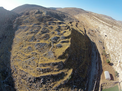
The
ruins are better visible in the following view - from the south east side. The
hill is surrounded by two valleys - the deep Samiya gorge on the left (west)
side, and the wider valley of Wadi el-Saiya on the right (east) side.
On
the hill are heaps of stones, which gave the site its Arabic name Marjameh.
According to the archaeologists, the heaps are remains of massive structures of
the Iron Age. There remains of the houses are arranged in terraces along the
slope of the hill. Between the ruins of the structures are winding streets that
go up the hill.
Khirbat Marjama is the largest ruin in eastern
Samaria. According to archaeologists, it had a constant population both in the
times of the Canaanite and during the reign of the Jewish kings of Israel. In
fact, archaeologists were able to uncover the city wall and guard tower from
the time of the kings. Remains from many other time periods have also been
found there including a flour mill, burial caves from the time of Abraham, and
the remains of houses.
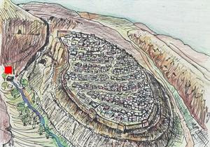


The
location of the spring is indicated on the illustration as a red square.
The
Samiya spring is the reason why the site was settled through thousands of
years. The dry desert area cannot support more than few shepherds, while the
Canaanite/Israelite city, and later the Roman/Byzantine town, required a steady
source of running water.

As soon as the archaeologists arrived on the scene,
they asked themselves what kind of important city existed there during these
time periods. Several suggestions were made to identify the site.
Now it is time for you to come, visit and walk in
the footsteps of Joshua.
Givon was the location of the battle between Abner
the son of Ner and Joav the sone of Zeruiah, both of whom were great generals
in the days of King David.


In addition,
the Arabic name Khirbat Marjama translates to ‘The Ruins of the Stone Heaps’
and the Hebrew name ‘Ai’ or ‘Aiyim’ translates to ‘Stone Heaps’.


